In a webinar organized by Transformative Urban Mobility Initiative (TUMI), Trufi’s Leonardo Gutierrez and Denis Paz Jimenez presented on how technologies such as OpenStreetMap (OSM), General Transit Feed Specification (GTFS), and open source journey planner applications contribute to improving operations, service quality, and societal benefits. The webinar was on November 2, 2022.

The Praxis of Trufi Transport Data
Jimenez discussed the various levels at which the data digitized by Trufi can be developed, consumed, and iterated – the praxis of transport data. The Data Collection Level usually begins with mapping public transport routes into OSM. Once the transport data is in OSM, it can be converted into GTFS, a form that can be processed and analyzed by applications such as our journey planner apps. Where cities have other mobility services and amenities – trains, bike paths, ridesharing, taxis, car charging stations, etc. – Trufi applications can integrate multiple services into a single app (such as our stadtnavi app for Herrenberg, Germany).
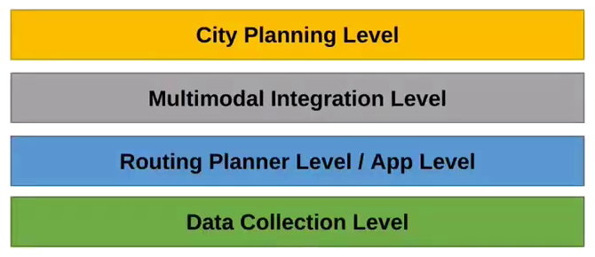
All of these data layers and sources can combine to inform transport planning – the “City Planning Level” – and also academic research. This level of the praxis is particularly powerful when combined with usage data generated by the apps, and user survey data.
More information on the webinar is available on the TUMI website.
Pingback: weeklyOSM 648 – weekly – semanario – hebdo – 週刊 – týdeník – Wochennotiz – 주간 – tygodnik